
VNMAP GIS – Multi-Layer Digital Map for Modern Management
A 2D and 3D digital mapping platform, fully developed in Vietnam with Vietnamese data, providing digital map services for urban planning, land use, agriculture, transportation, and digital addressing. The platform is designed to connect and integrate with various applications and software systems, delivering comprehensive and optimized solutions for e-government, enterprises, and other sectors.
VNMAP GIS – Multi-Layer Digital Map
Providing 2D/3D digital maps with integrated data:
Planning
Environment
Infrastructure
Economy & Society
Suitable for local government management and infrastructure enterprises.
Main Features
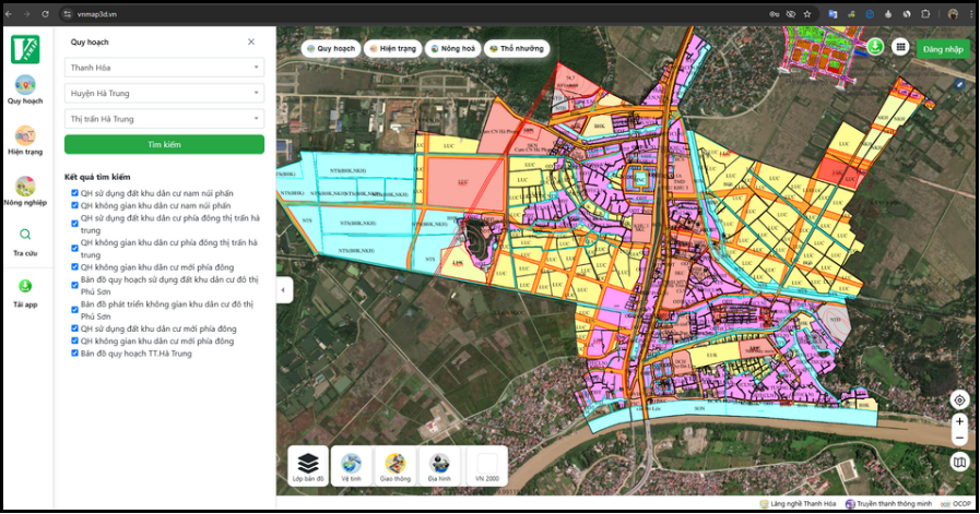
Multi-layer Digital Map Display
Crop areas, environment, tourism, planning, telecommunications, population...
Specialized Database Integration
OCOP, agriculture, telecommunications, transportation, broadcasting - supporting source tracing and spatial-temporal change tracking
Online Software Services
APIs/SDK for locations, routes, paths integrated into enterprise platforms, software, and websites
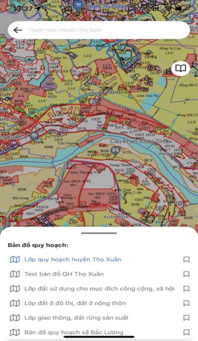
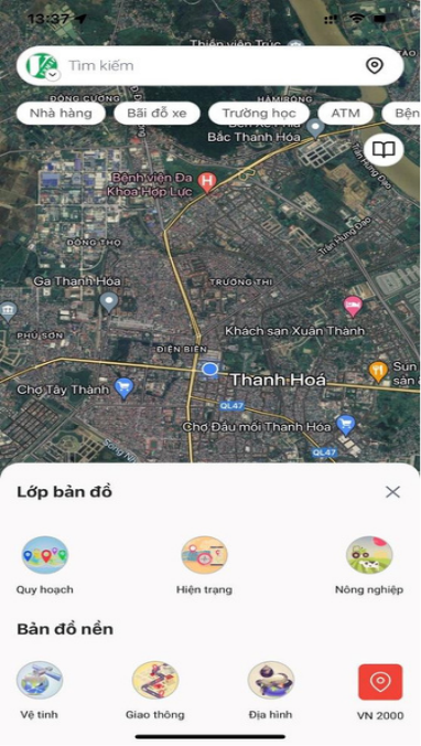
Mobile Application Integration
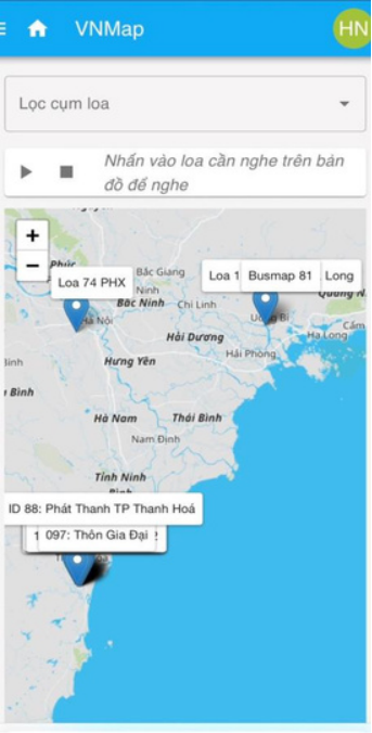
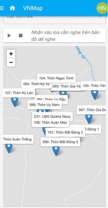
VNMAP (iOS, Android) and extension modules: environment, tourism, digital broadcasting
VNMAP Objectives
Support Digital Transformation
Support digital transformation at local, regional, and national levels
Enhance Transparency
Increase transparency and efficiency in infrastructure, resource, and product management
Create Shared Data Platform
Provide API rental for multiple sectors: agriculture, urban, telecommunications, education, healthcare
Apply Advanced Technology
Apply 3D technology, AI, and digital maps to serve e-government and smart cities
AI Application in VNMAP
Land Data Analysis
Land Data Analysis
Based on large land datasets from the system, AI can analyze and process to provide insights helping predict land use trends and support planning
Land Monitoring and Management
Land Monitoring and Management
AI combined with GIS technology helps monitor land use status, detect violations, and optimize resource management
Urban Planning Optimization
Urban Planning Optimization
AI supports urban development planning by analyzing population density, traffic, and infrastructure
Environmental Impact Assessment and Monitoring
Environmental Impact Assessment and Monitoring
AI helps assess the impact of land planning on the environment and propose measures to minimize negative effects
Planning Process Automation
Planning Process Automation
AI supports land use planning by automatically analyzing data and proposing optimal solutions

Soil Quality Analysis (Agriculture)
Soil Quality Analysis (Agriculture)
Analyze sensor data to assess soil moisture, nutrients, and pH levels, helping farmers adjust farming methods appropriately

VNMAP Solution Interface
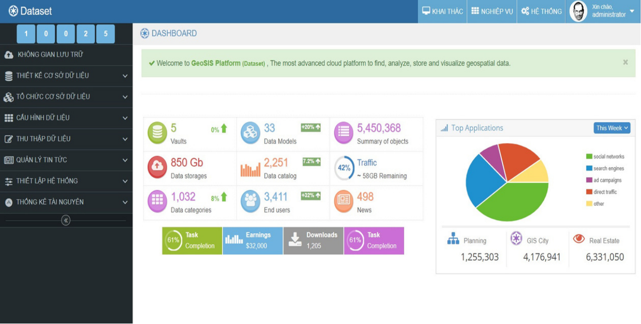
Platform Features
Data Storage Technology
A platform capable of storing multi-component digital map data
VnMap3D's technology develops a sustainable map platform. It is flexible, inheritable, and expandable. In addition, it has diverse display capabilities such as 2D, 3D, and 4D.
Ability to share data with other systems:
- API/SDK
- Payment gateway
- Notification channel
- Platforms, software belonging to state and business sectors

Admin Center
Centralized management, storage, exploitation, and transaction statistics
Centralized data management software via a web interface, users can access and update anytime, anywhere. User-friendly interface, flexible tools, continuous update capability, adapting to all user interactions.
Provides an environment for storing, updating, and exploiting transaction history and customer access, with flexible function design, suitable for multiple industries and fields.
Allows for chart statistics and flexible report generation according to diverse requirements, helping organizations manage customers easily and effectively.

API, SDK
Building an open API/SDK set for integration with other systems
The platform meets compatibility and flexibility in connecting with other systems such as: systems of state agencies, systems of enterprises, other value-added service systems,...
With high scalability, easy integration with existing systems, customization, and open design, it meets the business requirements of different fields.
Provides open APIs to retrieve data for integration with systems:
- API/SDK integration for user business logic
- API/SDK integration for 2D, 3D, 4D map data business logic
- API/SDK integration with external systems and services
- API/SDK for point, area, and detailed object information data business logic
- API/SDK for data reconciliation

Protocols
Platform Communication Standards
VNMap3D builds a set of standard protocols to connect and exchange data with other software over the network infrastructure.
Defines data communication messages: Specifies the structure and format of data in the message.
Builds a data security solution in every process.

Toolkits
Support Tools
Supports tools for checking if data information is valid and accurate.
Supports tools for converting data according to specified standards.
Supports flexible data entry tools.

Integrations
Ready to integrate with other platforms and software systems
VnMap3D, with its solution for inheriting and expanding integration channels and sharing data with large existing platforms, helps to implement quickly, conveniently, and reduce costs.
The platform always aims to ensure data completeness, and the ability to share and exploit information.
Has a mechanism for integration with other information systems; has the ability to be commercialized and save costs in developing applications according to business requirements based on the platform.

Target Customers
| Customer Group | VNMAP Application Role | Description | Examples |
|---|---|---|---|
| Provincial Government / DNDH Office | Manage land planning, monitor crop areas | DNDH Thanh Hoa, Ha Tinh | Land management |
| Commerce / Agriculture Office | OCOP, crop areas, agricultural product management | Ha Nam, Bac Giang | Agricultural product management |
| Tourism / Culture Office | Craft village tourism, display local maps | Nghe An, Yen Bai | Tourism |
| Digital Broadcasting Enterprises | Connect IP broadcasting systems, monitor transmission | Viettel, VTVcab, FPT | Broadcasting |
| District / Commune Government | OCOP retrieval software applications, broadcasting, alerts | Quang Binh, Lao Cai | Local management |
Product Positioning
| Criteria | VNMAP | Competitor (Google Map) |
|---|---|---|
| Data Source | Purely Vietnamese, tied to locality | Global, difficult to customize for Vietnamese administrative units |
| Specialized Applications | OCOP, broadcasting, crop areas | Mainly traffic maps and tourism |
| High Customization by Locality | Yes | No or very limited |
| AI - GIS Integration | Yes, environmental and land analysis | Very limited or not integrated |
| Software Copyright | Domestic copyright | Must rent or depend on international providers |
Solutions Built on VNMAP Digital Map Foundation
VNMAP DIGITAL DATA TRANSMISSION SOFTWARE
VNMAP BROADCASTING SOFTWARE

DECENTRALIZED ENVIRONMENTAL MONITORING SOFTWARE

Certificates & Awards


Ready to Experience VNMAP 3D?
Contact us today to schedule a demo or discuss how our 3D visualization solution can enhance your environmental monitoring and management capabilities.
Contact Us Now